
News / Local Infrastructure
22 July 2026
Priority for 12,000 new homes


Published 8:00am 10 October 2023
By Ella Bradford
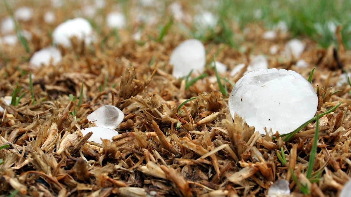
During storm season which runs from October to the end of April in Queensland, severe storms with hail, lightning, damaging winds and flooding are more likely to affect the City of Moreton Bay.
Severe hailstorms have the potential to damage homes and cars and cause life-threatening injuries and we’re being told to expect more of them.
Bureau of Meteorology Senior Meteorologist Shane Kennedy says all sized hail can pose a risk to people and property.
“Particularly large hail (10cm or more) is a risk to life, as it can be travelling at more than 100km/h (the terminal velocity or speed a falling object can reach will increase with the mass of the hail),” Shane says.
“Accumulations of small hail can also have an impact, as the sheer amount of hail can block gutters and drains making flash flooding more likely (or cause water to leak into roofs). The weight of it can also damage structures (collapse the roof) and bury crops.”
Hailstones are clumps of layered ice that form in the rising air within thunderstorms called updraughts.
Hailstones start as water vapour condensing into tiny water droplets inside the updraught.
When droplets are swept upwards into, or form inside the middle parts of thunderstorm clouds they become super-cooled.
This means they are still liquid but they’re colder than zero degrees Celsius.
They freeze into small ice balls called hail embryos if they meet tiny particles in the air like dust, dirt, or salt crystal.
Fully grown hailstones form in the hail growth zone, where the updraught air temperature is -10 to -25 degrees Celsius.
Hail embryos collide with super-cooled water droplets, causing them to freeze on impact.
When hailstones collide with enough droplets, they build in size and are heavy enough to sink faster than the upward air motion.
They then begin to fall.
Large hail is most common in Australia during spring and early summer.
During this period, surface temperatures are warm enough to form intense thunderstorms and the upper atmosphere is still cool enough for hail growth.
Hail tends to be smaller in winter due to showers and thunderstorms not having the same strong updrafts.
Shane says hail can happen year-round in Australia.
“For Queensland, we see most of our severe thunderstorms from late September to April,” Shane says.
“Severe thunderstorms producing large or giant hail are more likely in spring and autumn (Sept-November, and March-April), when the atmosphere is more unstable with stronger winds above the surface. These conditions make severe thunderstorms with damaging winds and large hail more likely.”
Giant hail is larger than five centimetres in diameter.

The Bureau of Meteorology issues a severe thunderstorm warning when thunderstorms are expected to produce one of the following:
· Large hail with a diameter of at least two centimetres
· Wind gusts of at least 90km/h
· Very heavy rain conductive to flash flooding
· Tornadoes
Giant hail warnings are added when hail larger than five centimetres’ across is expected.
Severe thunderstorm warnings typically have a lead time of three hours as they are difficult to predict.
When severe thunderstorm warnings broadcast, it is important to notice the warning, treat the thunderstorms during this period with caution and listen to the emergency services.
During all thunderstorms it is important to:
· Move indoors
· Avoid using a landline phone for lightning danger
· Avoid touching brick, concrete and standing barefoot on concrete and tiled floors
· Be cautious when driving
When strong winds or hail are forecast, it is important to put vehicles undercover and beware of fallen trees and power lines.
Shane says defer to the advice of emergency services, but having an emergency kit and plan is always wise.
“If large (2cm) or greater hail is forecast, moving vehicles under cover and staying indoors is advised. Giant (5cm+) hail can be particularly destructive, so preparing for interruptions to transport and the potential for roof and window damage is advised,” Shane says.
To stay updated look at the latest weather warnings.


A Caboolture woman has won $150,000 on an Instant Scratch-Its ticket bought at Morayfield Shopping Centre, marking the region’s second major lottery win in just 24 hours.

Six Moreton Bay athletes are ready to shine at the 2026 Commonwealth Games in Glasgow, with swimming star Sam Short leading the region’s medal hopes in a packed competition schedule.


Moreton Bay residents can enjoy a long weekend on Monday, August 10, for the 2026 Ekka public holiday, with the Caboolture Family Fun Day offering free rides and family entertainment.

The Pyjama Foundation is changing the lives of Moreton Bay foster children this pyjama day, with volunteers helping build confidence, literacy and brighter futures through weekly mentoring.

A Caboolture couple won more than $53,000 playing Keno at Sports Central Caboolture, with the jackpot helping fund home renovations and a dream holiday.

An appeal has been lodged against Moreton Bay City Council’s refusal of a proposed driving range at the former North Lakes Golf Course, with the dispute now heading to court.

RSL Queensland veterans have received a team-signed Dolphins ANZAC Round jersey as Ausbuild and the Dolphins extend their community partnership through to 2029.

A miniature version of the iconic 1982 Commonwealth Games mascot Matilda has arrived at The Mill playground in Petrie, giving Moreton Bay a nostalgic new attraction.